Occupation Summary

Surveyors

O*NET 17-1022.00

Description:

Make exact measurements and determine property boundaries. Provide data relevant to the shape, contour, gravitation, location, elevation, or dimension of land or land features on or near the earth's surface for engineering, mapmaking, mining, land evaluation, construction, and other purposes.

Annual Wages:
$66,866.00
Employment Rate:
Employment is expected to increase by 17.13%.
Education Level:
Bachelor's Degree. According to O*Net, the majority of people employed in this occupation have this level of education.
Endorsement:
Business and Industry, Science Technology Engineering and Math (STEM)

  1. Prepare and maintain sketches, maps, reports, and legal descriptions of surveys to describe, certify, and assume liability for work performed.
  2. Verify the accuracy of survey data, including measurements and calculations conducted at survey sites.
  3. Direct or conduct surveys to establish legal boundaries for properties, based on legal deeds and titles.
  4. Record the results of surveys, including the shape, contour, location, elevation, and dimensions of land or land features.
  5. Calculate heights, depths, relative positions, property lines, and other characteristics of terrain.
  6. Prepare, or supervise preparation of, all data, charts, plots, maps, records, and documents related to surveys.
  7. Write descriptions of property boundary surveys for use in deeds, leases, or other legal documents.
  8. Plan and conduct ground surveys designed to establish baselines, elevations, and other geodetic measurements.
  9. Search legal records, survey records, and land titles to obtain information about property boundaries in areas to be surveyed.
  10. Coordinate findings with the work of engineering and architectural personnel, clients, and others concerned with projects.
  11. Adjust surveying instruments to maintain their accuracy.
  12. Establish fixed points for use in making maps, using geodetic and engineering instruments.
  13. Determine longitudes and latitudes of important features and boundaries in survey areas, using theodolites, transits, levels, and satellite-based global positioning systems (GPS).
  14. Train assistants and helpers, and direct their work in such activities as performing surveys or drafting maps.
  15. Analyze survey objectives and specifications to prepare survey proposals or to direct others in survey proposal preparation.
  16. Compute geodetic measurements and interpret survey data to determine positions, shapes, and elevations of geomorphic and topographic features.
  17. Develop criteria for survey methods and procedures.
  18. Develop criteria for the design and modification of survey instruments.
  19. Conduct research in surveying and mapping methods, using knowledge of photogrammetric map compilation and electronic data processing.
  20. Locate and mark sites selected for geophysical prospecting activities, such as efforts to locate petroleum or other mineral products.
  21. Survey bodies of water to determine navigable channels and to secure data for construction of breakwaters, piers, and other marine structures.
  22. Direct aerial surveys of specified geographical areas.
  23. Determine specifications for equipment to be used for aerial photography, as well as altitudes from which to photograph terrain.
  24. Testify as an expert witness in court cases on land survey issues, such as property boundaries.

Watch a video about Surveyors

Career videos are provided by: CareerOneStop.org


National Industry Employment Patterns


Industry % of Surveyors employed Annual Growth Rate
Architectural, engineering, and related services 70.8 0.15
Highway, street, and bridge construction 2.1 1.06


Labor Market Information


2022 Statewide average hourly wage $32.15
2022 National average hourly wage $34.16
2020 National employment 46,000
2020 Texas employment 5,008
Texas projected employment by 2030 5,866
Texas projected annual employment and Turnover openings through 2030 541


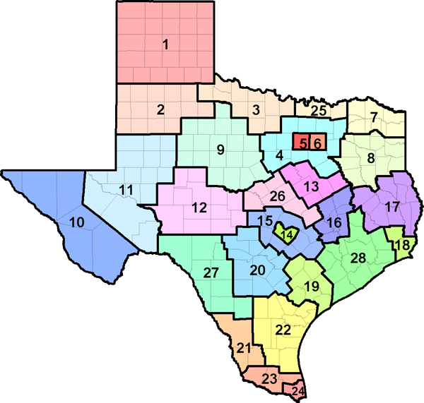
TEXAS COUNTY MAP BY WORKFORCE DEVELOPMENT AREA
* Due to confidentiality rules, not all regions may have the data displayed. The sum of all the regions may not be equal to the state total.


Top 10 Relevant Knowledge Areas Relevant Importance Levels
Mathematics
Knowledge of arithmetic, algebra, geometry, calculus, statistics, and their applications.
91.00%
Engineering and Technology
Knowledge of the practical application of engineering science and technology. This includes applying principles, techniques, procedures, and equipment to the design and production of various goods and services.
80.00%
Customer and Personal Service
Knowledge of principles and processes for providing customer and personal services. This includes customer needs assessment, meeting quality standards for services, and evaluation of customer satisfaction.
76.80%
Law and Government
Knowledge of laws, legal codes, court procedures, precedents, government regulations, executive orders, agency rules, and the democratic political process.
76.80%
English Language
Knowledge of the structure and content of the English language including the meaning and spelling of words, rules of composition, and grammar.
76.60%
Geography
Knowledge of principles and methods for describing the features of land, sea, and air masses, including their physical characteristics, locations, interrelationships, and distribution of plant, animal, and human life.
76.20%
Computers and Electronics
Knowledge of circuit boards, processors, chips, electronic equipment, and computer hardware and software, including applications and programming.
75.40%
Design
Knowledge of design techniques, tools, and principles involved in production of precision technical plans, blueprints, drawings, and models.
73.20%
Administration and Management
Knowledge of business and management principles involved in strategic planning, resource allocation, human resources modeling, leadership technique, production methods, and coordination of people and resources.
72.20%
Building and Construction
Knowledge of materials, methods, and the tools involved in the construction or repair of houses, buildings, or other structures such as highways and roads.
70.40%


Top 10 Relevant Skill Areas Relevant Importance Levels
Mathematics
Using mathematics to solve problems.
80.00%
Reading Comprehension
Understanding written sentences and paragraphs in work-related documents.
77.60%
Critical Thinking
Using logic and reasoning to identify the strengths and weaknesses of alternative solutions, conclusions, or approaches to problems.
77.60%
Speaking
Talking to others to convey information effectively.
77.60%
Active Listening
Giving full attention to what other people are saying, taking time to understand the points being made, asking questions as appropriate, and not interrupting at inappropriate times.
75.00%
Writing
Communicating effectively in writing as appropriate for the needs of the audience.
72.40%
Coordination
Adjusting actions in relation to others' actions.
70.00%
Time Management
Managing one's own time and the time of others.
70.00%
Judgment and Decision Making
Considering the relative costs and benefits of potential actions to choose the most appropriate one.
65.00%
Complex Problem Solving
Identifying complex problems and reviewing related information to develop and evaluate options and implement solutions.
65.00%


Top 10 Relevant Abilities Relevant Importance Levels
Written Comprehension
The ability to read and understand information and ideas presented in writing.
80.00%
Deductive Reasoning
The ability to apply general rules to specific problems to produce answers that make sense.
80.00%
Mathematical Reasoning
The ability to choose the right mathematical methods or formulas to solve a problem.
80.00%
Number Facility
The ability to add, subtract, multiply, or divide quickly and correctly.
77.60%
Oral Comprehension
The ability to listen to and understand information and ideas presented through spoken words and sentences.
77.60%
Oral Expression
The ability to communicate information and ideas in speaking so others will understand.
77.60%
Speech Recognition
The ability to identify and understand the speech of another person.
77.60%
Speech Clarity
The ability to speak clearly so others can understand you.
77.60%
Near Vision
The ability to see details at close range (within a few feet of the observer).
75.00%
Written Expression
The ability to communicate information and ideas in writing so others will understand.
75.00%


  • Making Decisions and Solving Problems
    -- Analyzing information and evaluating results to choose the best solution and solve problems.
  • Working with Computers
    -- Using computers and computer systems (including hardware and software) to program, write software, set up functions, enter data, or process information.
  • Getting Information
    -- Observing, receiving, and otherwise obtaining information from all relevant sources.
  • Documenting/Recording Information
    -- Entering, transcribing, recording, storing, or maintaining information in written or electronic/magnetic form.
  • Processing Information
    -- Compiling, coding, categorizing, calculating, tabulating, auditing, or verifying information or data.
Other Activities


  • Independence
    - Occupations that satisfy this work value allow employees to work on their own and make decisions. Corresponding needs are Creativity, Responsibility and Autonomy.
  • Relationships
    - Occupations that satisfy this work value allow employees to provide service to others and work with co-workers in a friendly non-competitive environment. Corresponding needs are Co-workers, Moral Values and Social Service.


Tools

Barometers: Barometers;

Clinometers: Clinometers;

Distance meters: Distance meters; Telescopic viewers;

Electromagnetic geophysical instruments: Magnetic locators;

Extension pole: Prism poles;

Geological compasses: Pocket transits; Geological compasses;

Global positioning system GPS receiver: Integrated global positioning systems GPS; Global positioning system GPS receivers;

Height gauges: Abney levels; Altimeters;

Instrument tripods: Elevator tripods; Tripods; Robotic tripods;

Interferometers: Tracking lasers;

Laser measuring systems: Automatic slope lasers; Line lasers; Handheld measuring lasers;

Lasers: Rotary lasers; Visible beam lasers; Dot lasers; Invisible beam lasers;

Level sensors or transmitters: Transit levels;

Levels: Hand levels; Electronic digital levels; Automatic levels;

Machetes: Machetes;

Map measurers: Curvimeters; Planimeters;

Measuring rods: Digital measuring poles; Direct elevation rods; Measuring rods; Philadelphia rods; Surveyors leveling rods; San Francisco rods; Rod levels;

Measuring tapes: Depth gauge tapes;

Measuring wheels for distance: Road measuring wheels;

Notebook computers: Laptop computers;

Optical calibration sets: Tribrachs;

Personal computers: Pocket personal computers PC;

Plumb bobs: Laser plumb bobs; Plumb bobs;

Prisms: Right-angle prisms; Double right-angle prisms;

Rangefinders: Digital laser rangefinders;

Scanners: Laser scanners;

Sonars: Side scan sonars;

Sonometers: Single-beam echo sounders; Single-beam transducers;

Tape measures: Gammon reels; Measuring tapes;

Theodolites: Prismless total stations; Reflectorless total stations; Robotic total stations; Total stations; Mechanical theodolites; Long range reflectorless total stations; Electronic digital theodolites;

Two way radios: Two way radios;

Video attachments for microscopes: Stereoscopes;


Technology

Analytical or scientific software: CE SURVEYOR III; Carlson SurvCE; Geocomp Systems GeoNav; Geodetic software; HYPACK HYSWEEP; HYPACK MAX; MicroSurvey FieldGenius; Surface modeling software; Survey software; Sokkia Spectrum Survey Suite;

Application server software: CloudWorks;

Computer aided design CAD software: Computer aided design and drafting software CADD; Carlson SurvCADD; CMT Incorporated CogoCAD; Bentley MicroStation; Autodesk AutoCAD; Autodesk AutoCAD Civil 3D; Autodesk AutoCAD Land Desktop; MicroSurveyCAD; Trimble Terramodel;

Data base user interface and query software: Data logging software;

Data conversion software: Cyclone;

Document management software: Data transfer software;

Geographic information system: Cadcorp desktop GIS; ESRI ArcGIS software; ESRI ArcView; Geographic information system GIS software; Geographic information system GIS systems;

Graphics or photo imaging software: Bentley GeoPak Bridge;

Information retrieval or search software: Topographic database software;

Internet browser software: Internet browser software;

Map creation software: Geomechanical design analysis GDA software; PC-Mapper software; Bentley Systems InRoads Suite; Drafting software; Carlson Survey; Trimble HYDROpro; Sokkia Imap;

Mobile location based services software: Global positioning system GPS software;

Office suite software: Latitude software; Microsoft Office software;

Project management software: Project analysis and costing software; Project data integration software; Crones & Associations Project Tracker Pro;

Route navigation software: NOAA Shoreline Data Explorer;

Spreadsheet software: Spreadsheet software; Microsoft Excel;

Time accounting software: Sharetech Tabs Plus;

Word processing software: Microsoft Word;


Related O*NET occupational titles for Surveyors include:
  • 13-2023.00 Appraisers and Assessors of Real Estate
  • 17-3011.00 Architectural and Civil Drafters
  • 17-1021.00 Cartographers and Photogrammetrists
  • 17-3022.00 Civil Engineering Technologists and Technicians
  • 17-2051.00 Civil Engineers
  • 47-4011.00 Construction and Building Inspectors
  • 17-1022.01 Geodetic Surveyors
  • 19-4043.00 Geological Technicians, Except Hydrologic Technicians
  • 17-2151.00 Mining and Geological Engineers, Including Mining Safety Engineers
  • 17-3031.00 Surveying and Mapping Technicians


Sources of Additional Information
  • For information about surveying, career opportunities, and licensure requirements, visit: National Council of Examiners for Engineering and Surveying
  • National Society of Professional Surveyors
  • For information about a career as a geodetic surveyor, visit: American Association for Geodetic Surveying
  • For a list of schools offering accredited programs, visit: ABET
  • Geodetic Surveyors
  • Surveyors

  • Contact Texas Workforce Commission
    Labor Market and Career Information  |  101 E. 15th Street, Annex Room 0252  |  Austin, Texas 78778
    Official Website  |  1-800-822-PLAN (7526)  |  512.936.3200

    ** The information in this report may be derived from many sources like O*NET, BLS (Bureau of Labor Statistics), OOH (Occupational Outlook Handbook), and Career One Stop.